BLUE ANCHOR - CLAIMED PUBLIC FOOTPATH
email sent to: Rights of Way, Somerset Council; January 2026
Strategic Planning Committee - Thursday, 22nd January, 2026 2.00pm
WILDLIFE AND COUNTRYSIDE ACT 1981 SECTION 53
Request to add a right of way in Carhampton Parish between
ST 02156-43479 and ST 01526-43596 Application 848M
I ask Somerset Council to determine this request to add this public right of way. This is in-line with the Council's local transport plan that includes a commitment to improving walking and cycling links in Somerset's coastal areas to "meet the needs of locals and visitors".
Until 2017, there was no access problem, and the public had been encouraged to use the footpath, shop and car park continuously since before WW2.
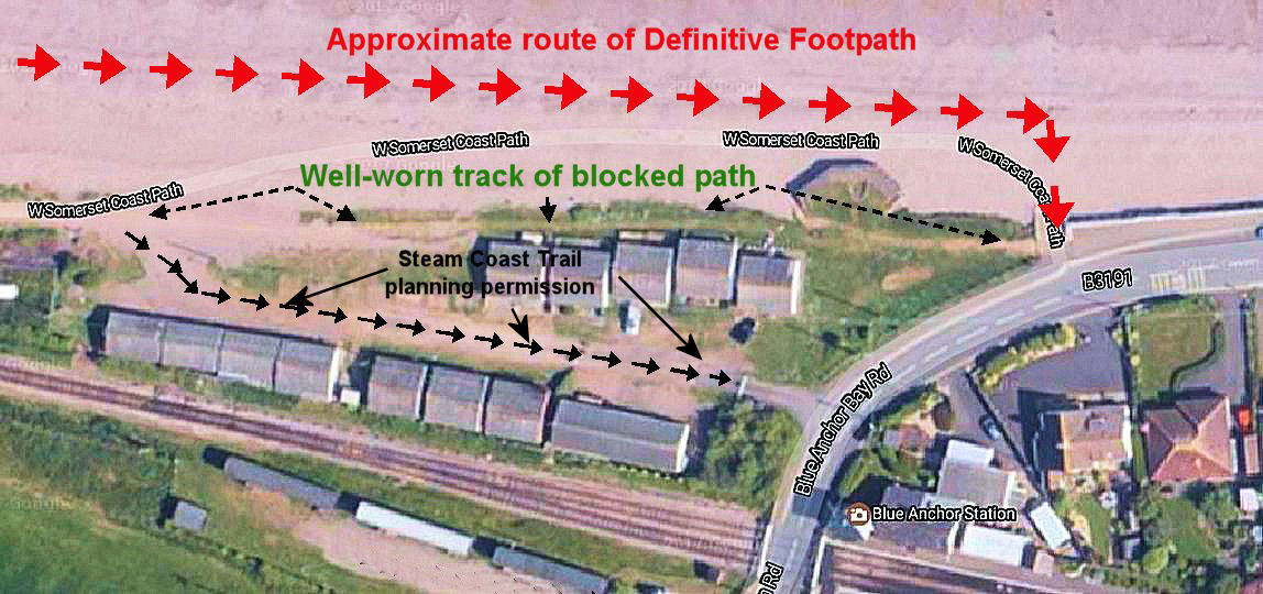
1. Although three paths (Coastal Path, Steam Trail and Public Footpath) are shown as having similar start and end points, they do not have the same intended use - one for serious walkers, one for cyclists and one for recreational walkers. Clearly, a path suitable for one use is not necessarily suitable for another, and they may or may not follow different routes.
2. The walked footpath (the wear path is clearly shown on Google street view) on the high land in front of the chalets is presently blocked, and access to the coastal strip towards Carhampton and Dunster has been severed. The claimed footpath has been used without challenge far in excess of twenty years (in practice, in perpetuity), as shown in many postcards of the period. This is also evidenced by 120+ signed forms by local people formally requesting reinstatement of the established Public Footpath, which have been properly deposited with County Footpaths.
3. The only evidence of a defined path is shown on the extant 1950s Definitive Map. The line on this map could have been added at any time, but its position is impractical, as it would have been under water for much of the time. This defined path is and was unusable, and was never signposted or used by recreational walkers for obvious reasons. As a Parish Councillor for 20 years, the Parish Council and I were not aware of this seaward Definitive Path until 2017. Had elected representatives been aware, we would most certainly have taken steps to correct the Definitive Map to show the actual footpath used by walkers on the high land immediately in front of the chalets long before any dispute arose.
4. The new alternative route now provided requires users to walk down steep steps, across an open beach and up a steep shingle bank. This new Definitive Public Footpath (the beach path) poses serious health and safety risks to members of the public and, according to the Equality Act 2010, discriminates on the basis of age and disability. The dangers are acknowledged by the County Council's warning signs, which effectively prevent a significant section of the community from accessing the onward defined footpath to Carhampton and Dunster.
5. The previous Chalet Site owner has (in writing to the Steam Coast Trail), raised no objection to public use of any part of the site. This validates the Ramblers Association's claims of unchallenged use for over 20 years prior to 2017.
6. The West Somerset Coastal Path document, issued by the County Council, states at Section 9, travelling westwards from the top of the steps, "Follow the public footpath on the beach side of the chalets. To your right is another piece of WW2 defence infrastructure . . . .". This public right-of-way on the higher ground was acknowledged and promoted by the County Council.
7. Ordnance Survey clearly shows (and always has done) the footpath on the higher land immediately in front of the chalet site. Ordnance Survey have confirmed to me that "The most likely source for this Right of Way (ROW) would have been the Somerset Definitive Map. Comparing the current definitive map and the alignment of footpaths on our mapping, they are in agreement." Might there have been more than one version of the Definitive Map - one with the impractical Definitive Path line drawn out to sea, and one showing the Claimed Path 848 ?
8. The visit and report by a Government Inspector in 2014 saw the "clearly walked route" and noted (para 26) that "where there is more than one existing walked line or the definitive line of a public right of way differs from the line already walked on the ground, it is the walked line that is normally proposed." This anomaly followed private meetings between The Steam Coast Trail and the Chalet Site owners - private as the public and Parish Council were not involved, and so were unable to point out the historic and then current public footpath.
In practice, an important link to the coastal strip, well-signed (see 1999 postcard) and with proven use for many years, is now denied to many pedestrians in this prime holiday area. I feel that the level of use and the very real discrimination against residents and holidaymakers meet the criteria for requesting the reinstatement of this important footpath.
I have attached a (rather long) explanatory .pdf document to this email that outlines my three reasons for concern and the reasoning behind them, including maps and period postcards to demonstrate the long-term (exceeding 90 years) unrestricted use of the claimed footpath.
I believe that "Once a footpath, always a footpath" is the law.
Our family goes back over 50 years to when the public was actively invited onto the chalet site to use the shop and other facilities.
I ask you, after visiting the site, and with the evidence at hand, to take steps to reinstate our footpath.
Best wishes from Jim Butterworth
Former District Councillor (4 years) and Carhampton Parish Councillor (20 years)